The Haines Highway is one of the most spectacular drives in the North. In 2009 it was awarded the distinction of National Scenic Byway and when you drive it you will understand why. The Highway is 247 km long and is an excellent road. It essentially follows the trail used by the Chilkat / Tinglit First Nations who traded with the Athabascan First Nations in the interior of the Yukon. It was originally called the “Grease Trail” as the main commodity was oil from the candle fish found in the ocean near Haines. In the late 1800s the trail was improved by Jack Dalton, an explorer and white trader, who recognized the importance of the route and established several Trading Posts.
The trail was developed before the Klondike Gold Rush and the ever entrepreneurial Dalton charged a fee to hopeful miners on their way to the Klondike.
It is now part of the Golden Circle Route Which links Whitehorse, Skagway, Haines and Haines Junction. This route includes a one hour ride on the Alaska Marine Highway between Haines and Skagway. This is a highly recommend side trip on your Northern Adventure.
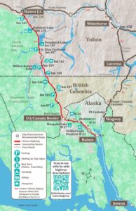
Haines Highway Map
This map of the Haines Highway shows the route from Haines Alaska, through British Columbia and the Yukon and ending in Haines Junction. At the junction, the Highway connects with the Alaska Highway. The complete Golden Circle Route is shown on this map.
What to see on the Haines Highway
Accommodations & Camping in Haines
Things To Do in Haines Alaska
Mile 18-21 – Chilkat Bald Eagle Preserve Viewpoints
There are numerous parking areas with views of the Alaska Chilkat Bald Eagle Preserve. The Haines Highway parallels the Preserve from mile 8 to mile 31.
The Council Grounds pullout at mile 19 has information boards, toilets, and a boardwalk.
The Bald Eagle Preserve is 48,000 acres has one of the highest concentrations of Eagles in the world. October and November see the most Eagle activity, but even during the summer, most visitors will easily spot one of these massive birds floating gracefully in the sky or perched high in a tree top.
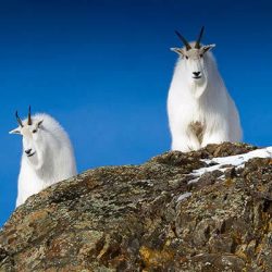
This area is also home to mountain goats, moose, and bears. To see Bald Eagles up close, visit the American Bald Eagle Foundation.
Alaska/Canada Border
At Mile 40 is the International Border. The border is open year-round. All traffic must stop at customs.
Million Dollar Falls Yukon Government Campground
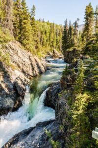
At Km 159.1. This Yukon Government campground is reached by a 1km side road. Amenities include picnic tables, toilets, shelter, and water. There are 33 sites and hiking trails. There is also a great view overlooking Million Dollar Falls.
Dezadeash Lake Yukon Government Campground
At Km 195.5, this campground has 20 sites, toilets and a boat launch. There is no drinking water available. Dezadeash Lake is shallow and 15 miles long with good fishing for lake trout, northern pike, and grayling. Storms can come up quickly here, so be aware.
Kathleen Lake Campground
At km 219.6, Kathleen Lake Campground has 39 campsites, water, toilets, picnic tables, hiking trails, a boat launch and fishing for lake trout and grayling. This is one of the most beautiful lakes in the Yukon.
Kathleen Lake is the easiest access to explore Kluane National Park without venturing into the backcountry. There is a day use area with boardwalk, boat launch and picnic area with incredible views of the lake and surrounding mountains.
Haines Junction
Haines Junction is at Km 246 if the Haines Highway and Km 1578.5 of the Alaska Highway. This small community of approximately 800 is nestled at the base of the St. Elias Mountains and is the headquarters for Kluane National Park.
Haines Highway FAQs
Can you drive from Haines to Skagway?
Yes you can drive, but it is 350 miles/563 km. Despite the fact that Haines and Skagway are only 14 miles apart, there is no direct Road. To drive from Haines, take the Haines Highway, the Alaska Highway and the South Klondike Highway.
Is the Haines Highway Paved?
Yes the entire 152 mile length of the Haines Highway is paved and in good condition. The Haines Road is one of the best highways in the north.
Is Haines Junction the same as Haines Alaska?
Haines Junction is in the Yukon at the opposite end of the Highway from Haines. Haines Junction is the Junction of the the Haines Highway and the Alaska Highway. Hence the name.
How far is Haines from the Canadian Border?
Haines is 40 miles south of the Canadian Border.
